
The National Trails Hikers Choose Most
“Favorite” gets abused in outdoor media, so let’s be precise. In this context, America’s favorite National Trail System hikes are the routes that consistently attract the highest combination of permit demand, thru-hiker attempts, section hiking traffic, volunteer investment, and long-term cultural relevance. These are not simply the most scenic trails, nor the hardest. They are the trails people actually plan years around, return to repeatedly, and use as benchmarks for long-distance hiking in the United States.
The National Trail System includes hundreds of designated trails, but only a small group has achieved this level of sustained national engagement. The ten below dominate real-world hiking behavior—not because of hype, but because their design, access, and community infrastructure work.
Appalachian Trail
Stretching more than 2,190 miles from Georgia to Maine, the Appalachian Trail is the most traveled long-distance hiking route in the United States. Its popularity is driven by unmatched infrastructure: shelters, trail towns, water access, and a century-old volunteer network that lowers the barrier to entry. For first-time thru-hikers, it offers forgiving logistics, frequent resupply points, and a social culture that helps people finish. No other trail has produced more completions, repeat hikers, or community continuity.
Appalachian Trail Planning Guide
First-time thru-hiker execution
- The Appalachian Trail is uniquely suited to first-time thru-hikers because mistakes are recoverable rather than trip-ending rather than catastrophic.
- Frequent road crossings, trail towns, and bailout points allow hikers to adapt pacing, gear, and health in real time instead of pre-locking decisions.
- Success depends more on injury prevention, daily consistency, and recovery discipline than on advanced navigation or technical skill.
- The National Park Service defines the trail’s official scope, access points, and management framework, which explains why contingency planning is built into the route.
Shelter system and resupply cadence
- The shelter network subtly shapes daily mileage by clustering common stopping points roughly every 8–15 miles in many sections.
- Town spacing enables resupply every 3–5 days, keeping food carries short and reducing planning complexity for long stretches.
- Overusing shelters during peak season increases exposure to overcrowding, noise disruption, and illness transmission.
- Experienced hikers treat shelters as optional tools rather than fixed endpoints and plan flexible resupply buffers instead.
Northbound vs southbound trade-offs
- Northbound hikes offer gentler early terrain and strong social momentum but compress hikers into narrow seasonal start windows.
- Southbound hikes reduce crowd pressure and shelter competition but demand higher early fitness and cold-weather tolerance.
- Flip-flop itineraries balance weather and crowd exposure but introduce additional transportation and coordination complexity.
- Direction choice should be driven by injury risk tolerance and climate preference rather than tradition or social pressure.
Crowd management and start windows
- March and early April start dates create crowd compression in Georgia that affects pace, campsite access, and recovery quality.
- Earlier starts increase cold exposure, while later starts raise heat and storm risks farther north in the Mid-Atlantic.
- Crowd-aware hikers mitigate pressure by delaying starts, beginning north of Springer Mountain, or planning early zero days.
- Managing crowds is ultimately about protecting sleep, hygiene, and morale across a multi-month effort.
Pacific Crest Trail
Running 2,650 miles from Mexico to Canada, the Pacific Crest Trail represents the next step up in commitment and complexity. Snowpack management in the Sierra Nevada, long water carries in Southern California, and remote stretches in Oregon and Washington demand advanced planning. Despite these challenges, permit demand routinely exceeds quotas, and thru-hiker numbers have remained high for over a decade. The trail’s appeal lies in its dramatic elevation, ecosystem variety, and sense of scale.
Pacific Crest Trail Planning Guide
Permit-driven thru-hiker execution
- The Pacific Crest Trail requires advance permit planning, which turns execution into a timing problem before the hike even begins.
- Annual long-distance permits cap daily starts, shaping who can hike continuously versus who must section or flip.
- Failure to secure permits forces route changes, delayed starts, or fragmented itineraries.
- The Pacific Crest Trail Association manages permits, long-distance rules, and official trail guidance, making it the authoritative execution reference.
Desert water and heat management
- Southern California defines the PCT experience through heat exposure, long water carries, and limited shade rather than elevation gain.
- Water availability fluctuates yearly, forcing hikers to adapt mileage and carry capacity dynamically.
- Overconfidence in desert pacing leads to dehydration, injury, and early exits.
- Successful hikers plan conservative water margins and accept slower progress until conditions stabilize.
Sierra Nevada snowpack decisions
- Snowpack in the Sierra Nevada determines whether a thru-hike remains continuous or requires alternates and delays.
- High snow years compress hikers into short melt windows, increasing risk at passes and river crossings.
- Low snow years allow earlier entry but increase exposure to cold nights and fast runoff.
- Execution success depends on flexibility, traction skills, and realistic risk assessment rather than fixed calendars.
Remoteness trade-offs north of California
- Northern California, Oregon, and Washington introduce longer food carries and fewer bailout options than the southern sections.
- Trail tread improves, but wildfire closures and late-season storms complicate planning.
- Resupply errors in these regions have higher consequences due to distance between towns.
- Experienced hikers adjust by overplanning food buffers and monitoring closure updates continuously.
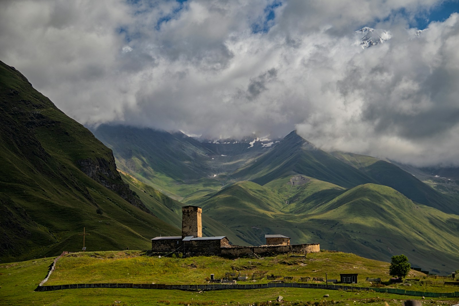
John Muir Trail
At roughly 211 miles, the John Muir Trail is short compared to other favorites, but its prestige is unmatched. It concentrates the most dramatic sections of the Sierra Nevada into a single corridor linking Yosemite Valley with Mount Whitney. Strict permit limits and high competition have not reduced demand; they have increased its perceived value. For many hikers, this is the most beautiful long-distance trail they will ever walk.
John Muir Trail Planning Guide
Permit-limited thru-hiker execution
- The John Muir Trail is governed by permit scarcity rather than distance, turning access into the primary execution constraint.
- Demand far exceeds supply, forcing hikers to plan months ahead or accept alternative entry points.
- Failure to secure a permit often results in abandoned plans or fragmented itineraries.
- The National Park Service explains the official permit process, quotas, and corridor rules through Yosemite National Park, which anchors all legitimate planning.
Northbound vs southbound strategy
- Northbound hikes start at lower elevation and build gradually, easing acclimatization for most hikers.
- Southbound hikes begin at high altitude and immediately test fitness and oxygen tolerance.
- Direction choice affects permit availability, resupply sequencing, and psychological load.
- Most first-timers succeed by prioritizing acclimatization over tradition.
Altitude and acclimatization limits
- Sustained elevation above 10,000 feet makes altitude adaptation a continuous concern rather than a one-time hurdle.
- Rapid gains without acclimatization increase risk of headaches, fatigue, and early exit.
- Mileage expectations must drop compared to lower-elevation trails.
- Successful hikers insert early low-mileage days to stabilize sleep and recovery.
Resupply scarcity and food planning
- Resupply options are limited and spaced far apart, increasing food weight and planning precision.
- Choices between on-trail resupply, bear canister capacity, and off-trail detours define daily comfort.
- Underestimating food needs leads to calorie deficits that compound altitude fatigue.
- Conservative food planning consistently outperforms aggressive mileage goals.
Continental Divide Trail
The Continental Divide Trail spans about 3,100 miles from Mexico to Canada and follows the spine of the Rocky Mountains. It is less finished, less forgiving, and less crowded than the AT or PCT, which is precisely why experienced hikers seek it out. Route-finding, variable tread quality, and long remote sections make it a logistical challenge. Its growing popularity reflects a shift toward self-reliant, skills-based long-distance hiking.
Continental Divide Trail Planning Guide
- The Continental Divide Trail prioritizes navigation and judgment over continuous tread, making execution skill-based rather than mileage-based.
- Large sections require route-finding across alternates, forest roads, and lightly marked corridors.
- Poor navigation decisions compound quickly because bailout options are limited and distances are long.
- The Continental Divide Trail Coalition defines official routes, alternates, and stewardship priorities, which anchors all legitimate planning decisions.
Alternates and route trade-offs
- Unlike more defined trails, the CDT presents multiple viable alternates with different risk and reward profiles.
- High routes offer scenery but increase weather exposure and snow risk.
- Lower routes reduce technical risk but may increase road walking or water scarcity.
- Successful hikers choose alternates dynamically rather than committing to a single line.
Snow persistence and seasonal risk
- Snow lingers unevenly across the Rockies, creating variable conditions even within the same state.
- Early-season hikers face dangerous passes, while late starters risk storms and closures.
- Fixed calendars fail on the CDT due to regional variability.
- Flexible pacing and contingency planning are essential for continuity.
Isolation and logistical gaps
- Extended remote stretches separate the CDT from more social long-distance trails.
- Resupply points are fewer and farther apart, raising the cost of mistakes.
- Mental resilience becomes as important as physical conditioning.
- Experienced hikers plan food and fuel margins conservatively to buffer uncertainty.
Colorado Trail
At approximately 486 miles, the Colorado Trail offers high-alpine hiking without the multi-month commitment of a coast-to-coast route. It connects Denver to Durango through some of the most consistently scenic terrain in the Rockies. The trail’s popularity comes from its balance: challenging elevation, good signage, manageable resupply, and a realistic time frame for working hikers. It is often the first “serious” long-distance trail people complete.
Colorado Trail Planning Guide
Altitude-driven thru-hiker execution
- The Colorado Trail compresses sustained high-altitude exposure into a relatively short distance, making oxygen availability the primary execution constraint.
- Long stretches above 10,000 feet slow pace, disrupt sleep, and magnify minor fitness gaps.
- Pushing standard mileage targets from lower-elevation trails leads to burnout or injury.
- The Colorado Trail Foundation maintains definitive segment descriptions, elevation profiles, and access guidance, which anchors realistic execution planning.
Segment selection and pacing strategy
- The trail’s segmented design allows hikers to choose between continuous thru-hikes and staged section hikes.
- Early segments near Denver ease acclimatization, while later southern segments demand stronger conditioning.
- Poor segment sequencing increases altitude stress and recovery time.
- Successful hikers align segment order with acclimatization rather than calendar convenience.
Weather volatility above tree line
- Daily thunderstorms are common in summer, especially in exposed alpine sections.
- Lightning risk dictates early starts and conservative afternoon mileage planning.
- Ignoring weather patterns leads to rushed descents and unsafe ridge travel.
- Execution improves when hikers treat weather windows as immovable constraints.
Resupply towns and isolation trade-offs
- Resupply points are reliable but spaced far enough to require accurate food planning.
- Some towns require hitching or detours that add logistical friction.
- Underplanning resupply increases both weight and stress.
- Experienced hikers pre-map town access and accept occasional low-mileage days to stay flexible.
Superior Hiking Trail
Running 310 miles along Lake Superior’s North Shore, this trail punches far above its weight in loyalty and repeat use. Frequent access points make it ideal for section hiking, while rugged terrain and lake-effect weather keep it demanding. Its popularity is regional but intense, with hikers returning year after year rather than chasing novelty elsewhere. Few trails combine wilderness feel with logistical simplicity as effectively.
Superior Hiking Trail Planning Guide
Section-first long-distance execution
- The Superior Hiking Trail functions best as a section-based long-distance project rather than a single continuous push.
- Frequent access points allow hikers to build experience incrementally without committing to a full-season thru-hike.
- Treating it like a traditional thru-hike often creates unnecessary logistical pressure.
- The Superior Hiking Trail Association publishes authoritative access points, camping rules, and corridor management details, which anchors realistic execution planning.
Lake Superior weather volatility
- Proximity to Lake Superior creates rapid weather shifts that override regional forecasts.
- Cold rain, wind, and fog can appear suddenly even in summer.
- Underestimating lake-driven weather leads to exposure issues rather than mileage failure.
- Successful hikers plan conservative daily distances and carry full rain and insulation layers year-round.
Terrain density and pacing limits
- Short, steep climbs accumulate fatigue faster than mileage alone suggests.
- Average pace is slower than on smoother long-distance trails despite shorter days.
- Overestimating daily mileage increases injury risk.
- Pacing improves when hikers plan by elevation gain rather than miles.
Camping permits and access logistics
- Designated campsites and permit rules shape where days begin and end.
- Limited campsite capacity requires advance planning during peak periods.
- Ignoring permit structure leads to last-minute reroutes.
- Efficient itineraries align mileage goals with legal camping zones.
Arizona Trail
The Arizona Trail spans 800 miles from Mexico to Utah and showcases desert, canyon, and high-plateau ecosystems. Its appeal lies in seasonal flexibility and solitude rather than crowds or social culture. Long water carries, heat management, and limited shade create real constraints, but they also filter for committed hikers. Permit demand and thru-hike attempts have climbed steadily as desert hiking gains respect.
Arizona Trail Planning Guide
Water-driven thru-hiker execution
- The Arizona Trail turns water availability into the primary execution constraint rather than mileage or elevation.
- Long dry stretches force hikers to plan carries precisely and adapt daily goals to water reality.
- Misjudging water needs leads to dehydration, heat stress, and forced exits.
- The Arizona Trail Association maintains official water reports, closures, and trail conditions, which anchors all legitimate planning.
Seasonal heat and cold trade-offs
- Desert heat dominates southern sections in spring and fall, while northern sections experience snow and freezing nights.
- Starting too early increases cold exposure; starting too late raises heat risk and water scarcity.
- Fixed calendars fail because seasonal conditions shift dramatically by latitude and elevation.
- Successful hikers time progress to follow moderate temperatures rather than chasing arbitrary start dates.
Northbound vs southbound timing
- Northbound hikes avoid early northern snow but face intense southern heat.
- Southbound hikes mitigate desert heat but require comfort with early-season snow at higher elevations.
- Direction choice directly affects gear weight and daily pace.
- Optimal direction depends on personal heat tolerance more than tradition.
- Open terrain reduces visual navigation cues despite clear trail tread.
- Sun exposure compounds fatigue even on moderate mileage days.
- Overconfidence in navigation and pacing leads to cumulative errors.
- Conservative pacing and strict sun management outperform aggressive mileage targets.
Florida Trail
The Florida Trail defies the mountain-centric stereotype of long-distance hiking. Stretching roughly 1,300 miles, it crosses wetlands, pine forests, and subtropical ecosystems with unique challenges like flooding, wildlife, and navigation. Its popularity is driven by winter hiking conditions and accessibility for East Coast hikers. Those who complete it often describe it as harder than expected and deeply rewarding.
Florida Trail Planning Guide
Wetland-driven thru-hiker execution
- The Florida Trail shifts execution risk away from elevation and toward water, footing, and navigation through wetlands.
- Flooding, standing water, and uneven tread slow pace and increase physical fatigue even on short mileage days.
- Treating the trail like a dry-terrain thru-hike leads to injury and morale collapse.
- The Florida Trail Association publishes official reroutes, closures, and corridor updates, which anchors all legitimate planning decisions.
Seasonal timing and flood exposure
- Winter and early spring offer the most stable conditions, while summer heat and storms overwhelm most itineraries.
- Rainfall patterns can change passability week to week, not season to season.
- Fixed start dates fail when water levels rise unexpectedly.
- Successful hikers build timing flexibility and accept reroutes as part of execution.
- Trail continuity is interrupted by roadwalks that require heightened situational awareness and mental discipline.
- Navigation errors in flat terrain compound because landmarks are subtle and repetitive.
- Underestimating roadwalk fatigue increases injury risk.
- Execution improves when hikers treat navigation as an active task rather than a background function.
Wildlife and exposure management
- Encounters with insects, snakes, and alligators are routine rather than exceptional.
- Poor campsite selection increases exposure to pests and moisture.
- Fear-driven overreaction causes more problems than wildlife itself.
- Calm assessment and site discipline reduce risk and stress significantly.
Pacific Northwest Trail
Connecting Glacier National Park to the Pacific Ocean, this 1,200-mile route remains one of the least crowded favorites. Its reputation is built on remoteness, complex logistics, and limited trail development in places. Hikers drawn to it value isolation and cross-border wilderness continuity over amenities. While not mainstream, it commands intense loyalty among those who finish it.
Pacific Northwest Trail Planning Guide
Isolation-driven thru-hiker execution
- The Pacific Northwest Trail prioritizes solitude and continuity over infrastructure, making self-sufficiency the dominant execution requirement.
- Long stretches lack services, cell coverage, and reliable bailout options.
- Errors compound faster here because external support is limited.
- The Pacific Northwest Trail Association defines the official route, access updates, and stewardship priorities, which anchors all legitimate planning.
Access gaps and logistical friction
- Trailheads are unevenly spaced and often remote, increasing transportation complexity.
- Resupply points require advance coordination and conservative food planning.
- Underestimating access friction leads to schedule collapse rather than gradual delay.
- Successful hikers pre-plan transport and accept lower daily mileage to preserve margins.
Snow persistence and river crossings
- Snow lingers late in the season, especially near Glacier National Park and high passes in Washington.
- River crossings vary widely year to year, shifting risk profiles mid-hike.
- Fixed calendars fail due to localized conditions.
- Execution improves when hikers delay entry or reroute rather than force continuity.
Border and endpoint logistics
- Northern and western termini introduce border and coastal access constraints.
- Identification, permits, and transport timing affect start and finish feasibility.
- Poor endpoint planning creates unnecessary stress late in the hike.
- Treating endpoints as logistics projects rather than symbolic goals improves outcomes.
Ice Age Trail
The Ice Age Trail winds more than 1,200 miles through Wisconsin, tracing the edge of ancient glaciers. It is not a traditional thru-hike for most people; its popularity comes from modular design and community integration. Thousands of hikers complete sections annually, often returning repeatedly over years. Its success proves that long-distance hiking does not require remoteness to matter.
Ice Age Trail Planning Guide
Multi-year long-distance execution
- The Ice Age Trail is designed for completion over time rather than a single continuous season.
- Discontinuous segments and developing corridor sections make flexibility mandatory.
- Treating it like a traditional thru-hike often leads to frustration rather than progress.
- The Ice Age Trail Alliance outlines the trail’s evolving corridor, access points, and official completion pathways, which anchors realistic execution planning.
Section sequencing and continuity
- Logical section order matters more than geographic direction.
- Urban-adjacent segments provide easy access, while rural stretches demand more planning.
- Poor sequencing increases transport time and reduces hiking efficiency.
- Successful hikers cluster sections geographically to minimize logistical friction.
Urban–rural transition management
- The trail frequently alternates between natural areas and developed landscapes.
- Mental fatigue increases when expectations don’t match terrain reality.
- Overpacking for wilderness sections creates inefficiency in urban corridors.
- Adaptive gear choices improve comfort across mixed environments.
Year-round hiking constraints
- Snow, mud season, and heat each limit different sections at different times.
- No single season works equally well across the entire trail.
- Fixed completion timelines fail due to seasonal variability.
- Progress improves when hikers align sections with optimal local conditions rather than calendar goals.
Why These Trails Endure
These ten hikes endure because they solve real execution problems, not because they are merely scenic. Each offers a clear route identity, logistics that can be realistically managed, and stewardship organizations that keep information current and enforce standards. Some succeed by lowering barriers for first-time long-distance hikers, while others persist by rewarding advanced skills and self-reliance. What unites them is cultural momentum built through repeat use, shared knowledge, and institutional support. Trails lacking these qualities may be beautiful, but they fail to sustain long-term relevance once novelty fades.
How to Choose the Right One
The right trail is defined less by reputation than by alignment with your time, experience, and tolerance for uncertainty. First-time hikers tend to succeed on routes with dense access points, predictable resupply, and strong social infrastructure. Experienced hikers often prioritize isolation, navigational complexity, or unfinished corridors that demand judgment rather than routine. The long-term popularity of these trails reflects their ability to accommodate different definitions of success instead of enforcing a single hiking model.
Suggested States Near America’s Favorite Trails
These states act as primary logistical anchors for permits, access, resupply strategy, and recovery across multiple National Trail System hikes. Each state is listed once, even where it supports more than one trail.
California
California anchors more long-distance trail planning than any other state, supporting the Pacific Crest Trail, the John Muir Trail, and major sections of the Continental Divide Trail via access corridors. It combines desert entry logistics, high-alpine permit management, and wildfire-driven contingency planning in a single jurisdiction. Hikers planning western trails inevitably intersect California’s permit systems and seasonal constraints.
Colorado
Colorado forms the alpine core of both the Continental Divide Trail and the entire Colorado Trail. High elevation, weather volatility, and extended above-treeline exposure make it a decisive state for fitness, acclimatization, and pacing decisions. Planning failures here tend to cascade across entire itineraries.
Georgia
Georgia serves as the most common southern entry point for the Appalachian Trail and shapes first-time thru-hiker experience more than any other state. Early-season weather, crowd density, and terrain difficulty establish pacing habits that persist for months. Many Appalachian Trail outcomes are effectively decided here.
Virginia
Virginia contains the longest continuous stretch of the Appalachian Trail and functions as a pivot state for section hikers and long-distance continuity. Its moderate terrain allows recovery and recalibration after the southern Appalachians. Planning flexibility is highest here due to dense access points.
Oregon
Oregon provides lower logistical friction on the Pacific Crest Trail, with smoother tread and reliable trail towns. It is often where hikers regain momentum after more demanding sections to the south. For many, Oregon determines whether a PCT hike finishes strong or collapses late.
Washington
Washington anchors the northern terminus of the Pacific Crest Trail and the western terminus of the Pacific Northwest Trail. Snow persistence, river crossings, and late-season storms make it one of the most failure-prone states late in long-distance hikes. Strong planning discipline is essential here.
Montana
Montana serves as the northern anchor for the Continental Divide Trail and the eastern terminus of the Pacific Northwest Trail. Long wilderness sections and limited access elevate logistical risk. This state rewards conservative planning and penalizes optimism.
Arizona
Arizona contains the full length of the Arizona Trail and introduces extreme seasonal contrasts between desert and high plateau. Water scarcity and heat management dominate planning more than mileage. Errors here are immediate rather than cumulative.
Florida
Florida anchors the Florida Trail and redefines long-distance hiking around wetlands, flooding, and navigation rather than elevation. Seasonal timing is the primary determinant of success. Traditional thru-hiking assumptions often fail here.
Minnesota
Minnesota contains the full corridor of the Superior Hiking Trail and supports modular long-distance planning. Weather volatility and steep, repetitive terrain influence pacing more than distance. It excels as a repeatable, section-based state.
Wisconsin
Wisconsin supports the full length of the Ice Age Trail and is structured for multi-year completion rather than single-season execution. Urban–rural transitions require adaptive gear and expectations. Progress here favors persistence over endurance.
New Mexico
New Mexico anchors the southern terminus of the Continental Divide Trail and defines early-season success. Exposure, water planning, and long distances between resupply points establish discipline that carries north. Mistakes here compound quickly.
Fresh Travel Guides Worth Exploring
Gansevoort Turks + Caicos: Stay Longer, Pay Less
Discover how to maximize a Caribbean getaway using Gansevoort’s 3-for-2 resort deal—perfect for relaxing after a trail-heavy adventure or as your next long-stay reward.
7 Days in San Francisco: Plan + Budget
Use this 7-day San Francisco itinerary to explore coastlines, iconic hills, and urban hikes—timed and budgeted for real-world execution.
Best Skyscraper Observation Decks in the World
Trade trail views for skyline ones—explore the world’s most thrilling observation decks where architecture and altitude collide.
Fastest-Growing Destinations Travel Guide
Step off the trail and into the future with this fast-growing destinations guide, built for travelers exploring what’s next before the crowds arrive.
Rainbow-Chasing Travel: Best Places Worldwide
Shift your focus from ground to sky with these rainbow-chasing destinations shaped by season, mist, and light—nature’s version of elevation.


